Road News June 2026
- Kaiser Road closure starts June 15
- St. John’s Bridge entrance closure June 5-14
- Will the Biggi development help pay for Thompson Rd. improvements?
Kaiser Road closure starts June 15
Washington County will improve Kaiser Road, between Springville and Brugger roads, with a center turn lane, on-street bike lanes, and standard sidewalks, to accommodate growth in the North Bethany area. They will also add sidewalks along County-owned property on Brugger Road near Kaiser Road. The project is scheduled for completion in September 2027.
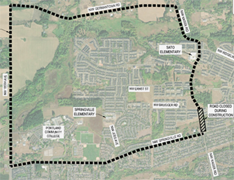
Kaiser will be closed from June 16 to August 16. The detour, via Germantown Road, 185th Avenue and Springville Road, is shown on the map. Pedestrians and cyclists may use neighborhood routes. An online Open House is open now, to help residents learn more about the project and make comments.
St. John’s Bridge entrance closure June 5-14
ODOT is restoring the bridge to improve safety and extend the life of the bridge on NW Bridge Avenue, northwest of the west end of the St. Johns Bridge. The bridge structure, built in 1930, consists of steel with concrete casing and now requires concrete repair to continue serving travelers.
A detour will be in place for vehicles traveling to and from the St. Johns Bridge. Coming off the bridge, travelers can take the south leg of NW Bridge Ave. to southbound NW St. Helens Rd (U.S. 30) to NW 4th Avenue to return to northbound St. Helens Road. Coming from NW St. Helens Rd. southbound or Germantown Rd., continue to the south leg of NW Bridge Avenue to access St. Johns Bridge eastbound. Work will be ongoing 24/7 at certain stages. Sidewalks and crosswalks will also close. People walking and biking will use U.S. 30 and south leg of NW Bridge Avenue to access St Johns bridge. Visit the project page for detour maps and more information.
Will the Biggi development help pay for Thompson Rd. improvements?
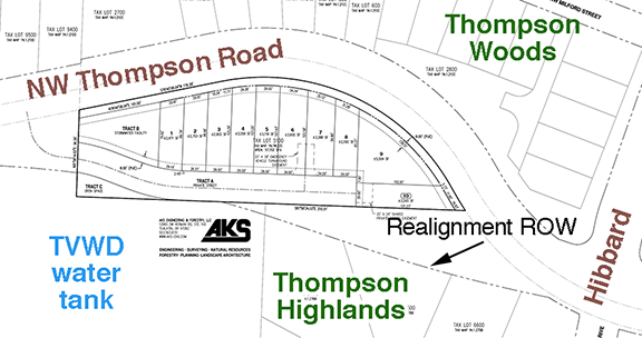
This spring, Biggi investments sought an extension for the Development Application, approved in 2022, for the proposed townhouse development on Thompson Road. Normally a new development would be required to pay for road improvements adjacent to and affected by the project. Since the Thompson Road improvement project is scheduled to begin in 2027, possibly before the development is begun, we asked Lauren Scott, Public Affairs & Communications Manager for Land Use and Transportation, about this. She said, “When the County is ahead of a development, we typically do not require the developer to build half-street improvements the County is delivering through a capital project, but the applicant would still be responsible for the Transportation Development Tax (TDT) and for dedicating Right of Way (ROW) because those obligations are part of their existing conditions of approval. The ROW appraiser will likely assign no compensable value to property already required by the conditions; compensation would apply only to property beyond what is conditioned. The project recently received a two-year extension, so the conditions remain active.” So it seems that the developer will pay their share of the improvements through the TDT that is collected when the Building Permit is issued.

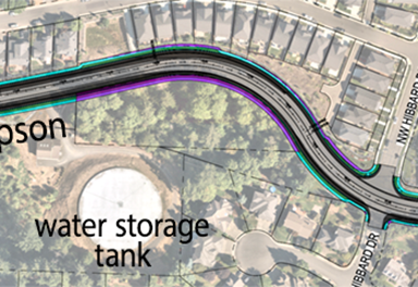
Scott also noted that while the full set of improvements will only go to Marcotte, the sidewalk will be extended to NW Permian. “These transition area improvements include continuing the south side sidewalk, adding curb and gutter, pavement widening, drainage features, and slope stabilization work so that the roadway ties smoothly into the existing infrastructure at NW Permian,” Scott said.